Geomagnetic change for the past 400 years
Geomagnetic change with time was found after the Age of Geographical Discovery. Moreover, people at the age might also know that diffrerent declination and inclination were observed in different place of the world. Mariners might measure declinations with combined observation of stars and magnetic directions.
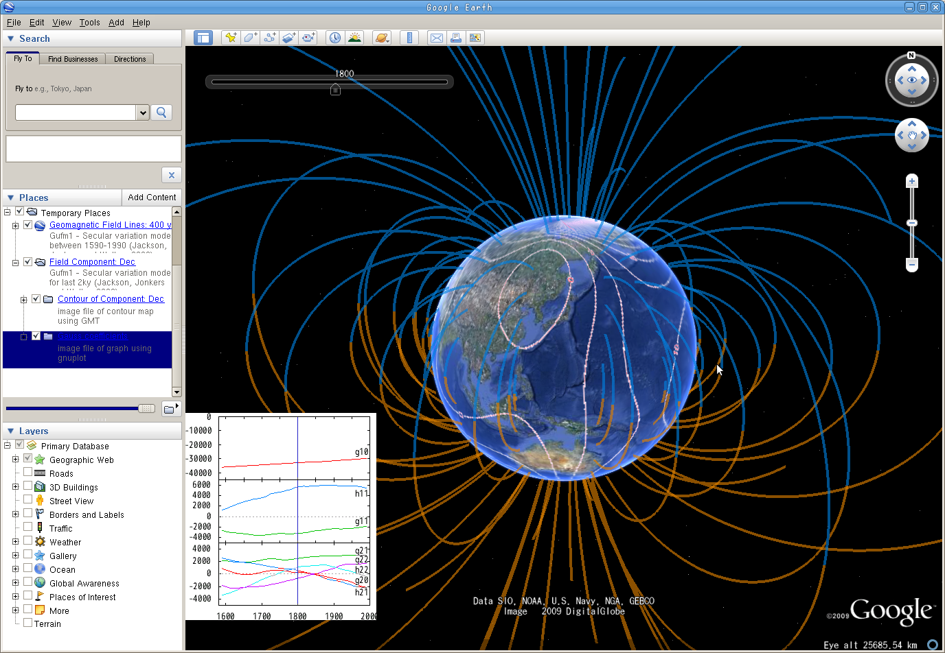
Dr. A.R.T. Jonkers in Leeds university, UK, compiled those geomagnetic data observed on ships. And Dr. A. Jackson, who is now in ETH, Swizerland, constructed a geomagnetic secular variation model duirng the last 400 years from those and other datasets (Jackson, Jonkers and Walter, 2000).
Here we introduce KML files indicating magnetic field lines and contour maps of the observable components derived this model.
Charts showing the change of the coefficients in low degrees of the spherical harmonic expanded geomagnetic potential, which is named the "Gauss Coefficients", are also contained in the KML file of the contour maps.
Snapshot, click to zoom up: Magnetic field lines and contour of declinations
KML files
- Magnetic field lines: Gufm1_MFL_20120308.kmz (47MB) HEAVY!
*modified for latest versions of Google Earth (2012/03/08) - Northward comp. Bx[nT]: Gufm1-Bx_20091128.kmz (10MB)
- Eastward comp. By[nT]: Gufm1-By_20091128.kmz (8.5MB)
- Downward comp. Bz[nT]: Gufm1-Bz_20091128.kmz (15MB)
- Field intensity F[nT]: Gufm1-Int_20091128.kmz (10MB)
- Declination D[deg]: Gufm1-Dec_20091128.kmz (15MB)
- Inclination I[deg]: Gufm1-Inc_20091128.kmz (10MB)
- Radial comp. Br[nT]: Gufm1-Br_20091128.kmz (15MB)
Reference:
Jackson A, Jonkers A. R. T. and M. Walker,
Four centuries of geomagnetic data from historical records,
Rev. Geophys., 41, 1006,
2000, doi:10.1029/2002RG000115.
Geomag past a century << Geomagnetic field past 400 years >> Geomag past 7000 years